Leonid Shumilo, Sofiya Drozd, Natalya Kussul
In this article the authors examine how satellite data can be used to comprehensively assess the economic and environmental impacts of war, including documenting the extent of damage and changes in land use as well as identifying prospects for restoring agricultural land without harming the environment.
Russia’s full-scale invasion of Ukraine, which began on February 24, 2022, has had a devastating impact on urban, industrial and agricultural infrastructure, as well as causing irreparable damage to the environment. Damaged and mined fields, destroyed infrastructure, resource shortages, and disrupted supply chains have resulted in the direct and indirect losses of tens of billions of dollars for farms. In addition to economic challenges, the agricultural sector has also suffered large-scale environmental losses: soil degradation, chemical pollution, erosion, destruction of irrigation systems and the rapid spread of invasive vegetation.
State of agricultural land in Ukraine at the beginning of Russia’s full-scale invasion
Ukraine has 42.5 million hectares of fertile land dedicated to agriculture. Before the war, the country was one of the largest exporters of grain and oilseeds, providing a significant share of the global market for wheat, corn and sunflower oil. Its contribution to food security in many countries in Africa, the Middle East and Asia was decisive. The lost access to Ukrainian grain as a result of Russian aggression has exacerbated global problems associated with rising food prices, logistical difficulties and resource shortages.
The war has also highlighted the global food system’s vulnerability to external shocks like armed conflict and demonstrates the need to develop innovative approaches to assessing damage and supporting the agricultural sector in times of crisis.
According to the World Bank in 2021, prior to the full-scale invasion, Ukraine’s agriculture sector accounted for about 10% of the country’s gross domestic product (GDP) and 41% of exports. Following decentralization and land use reforms in the 2000s, when approximately seven million citizens received land shares averaging four hectares in size, the added value of the agricultural sector doubled thanks to the formation of new small and medium-sized farms and an increase in the attractiveness of investment in Ukraine’s agricultural market. Today, about 20 million hectares (a third of Ukraine’s area) are cultivated by large farms often linked to foreign financial markets, 12 million hectares are used by small and mid-sized farms, and another 9.2 million hectares are owned by the state or communities (although much of this land has also been sold or privatized).
The modern structure of Ukrainian lands and land use methods were shaped during the Soviet period, when melioration technologies were actively promoted: irrigation in the steppe zone in the south and wetland drainage in Ukraine’s north. The creation of the cascade of hydropower reservoirs and large irrigation systems on the Dnipro River in southern Ukraine (an area containing the country’s most fertile chernozem soils) resulted in excessive growth in the share of arable land both relative to other agricultural lands and relative to the country’s overall surface area.
As of 2022, Ukraine’s arable land exceeded 56.8% of the country’s total area and supports Ukraine’s third-place global ranking for arable land. The extent of such changes in land use in recent decades plays a very significant role in anthropogenic impacts on the environment in Ukraine. Another factor is the insufficient oversight of land use, an issue that enables some farmers to use environmentally destructive practices that are prohibited by Ukrainian agricultural standards and recommendations. One example is the excessive cultivation of sunflowers—exceeding the ratio of one crop every seven years—which leads to mineral depletion and desertification. Further changes in land use should also be considered as important environmental factors.
The most destructive change in land use has been Russia’s full-scale invasion of Ukraine, which has resulted in land damage, soil contamination, mining, blight and temporary occupation of agricultural land.
Wartime challenges for agricultural production
Ukraine’s agricultural production since 2022 has faced three major challenges since the war’s start. The first of these is the restriction of grain exports. At the start of the war, roughly 20 million metric tons of grain (wheat and corn) from the 2021 harvest remained in storage. The blockade of Black Sea ports has significantly reduced export revenues, and high prices stemming from fuel and transport shortages threaten both producers and consumers. Alternative routes through Poland and Romania have limited throughput capacity. In addition, Russia carries out targeted missile strikes that destroy grain storage facilities, further worsening crop export logistics.
The second challenge is direct damage to lands caused by shelling, mining and the movement of military equipment, all of which reduce the productive potential of agricultural lands and create zones of temporary land use restrictions. In particular, these restrictions include temporary occupation, mining and, most importantly, chemical pollution. Depending on a complex set of political, social and environmental circumstances, the duration of such restrictions may vary in the future from months to centuries. Thus, temporary loss of access to agricultural lands can create vast zones of spontaneous vegetation growth, including dangerous invasive species.
The third challenge is related to resource shortages, in particular fuel, seed, fertilizer, pesticide and labor, which, taken together, create significant difficulties for small farms when it comes to growing winter crops and planting summer crops and inevitably affecting yields. For example, Kyiv School of Economics and the Ministry of Agriculture estimate total direct losses in agriculture to be $4.3 billion and indirect losses $23.3 billion in 2022. Indirect losses mainly result from logistics disruptions ($11.9 billion) and reduced production ($9.6 billion).
The production of major agricultural crops in Ukraine is highly sensitive to agrometeorological conditions that can cause interannual yield variations of approximately 10-20% depending on the type of crop. Winter crops, primarily grains, are especially sensitive to weather effects and climate change.
Coupled with low profitability and export challenges, climate instability has prompted the United States Department of Agriculture (USDA) to report a forecasted decrease in grain area in Ukraine in 2024-25. Yields are also expected to be lower than the near-record levels of 2023, when the grain area was large and weather conditions were favorable.
Destruction of the Kakhovka hydropower plant dam by Russian troops is an entirely separate challenge among the complex of new logistical problems caused by military actions. That dam’s destruction emptied the Kakhovka reservoir and ended irrigation works throughout Ukraine’s south.
Looking ahead, all of these challenges will necessitate a reaction by agricultural producers, who will most likely adapt to the new conditions by changing agricultural production methods, crop and land cultivation technologies and possibly by switching to fundamentally different methods of land use (livestock farming, growing energy crops, etc.)
Economic analysis of the war’s influence on food security
From the perspective of food security, it is very important to conduct an economic analysis of the war’s impact on the supply of agricultural products, a process which directly depends on production. However, it is impossible to make such an analysis using classical approaches and methods because of the challenges of accessing information in occupied territories.
The high degree of uncertainty in Ukrainian agricultural production has seriously undermined international food security, led to higher prices for agricultural products, and aggravated the situation in Ukrainian export-dependent countries in Africa, Asia and the Middle East. At the same time, most expert forecasts, as well as those of global analytical agencies, were very pessimistic at the beginning of the war.
For example, a July USDA report forecast the 2022 wheat harvest in Ukraine to be 19.5 million tons, 13.5 million tons less than in previous years. However, this estimate was significantly lower than Ukraine’s actual harvest. Ukrainian agriculture has proven to be much more resilient than anyone could have imagined.
Despite very pessimistic forecasts issued by global agencies and organizations, Ukraine was able to organize the harvesting of winter crops and the planting of summer crops in unoccupied territories in the first years of the full-scale war. At the same time, the State Service for Emergency Situations (SSES) worked efficiently to demine lands, allowing farmers to continue working in de-occupied or previously damaged fields. This work occurred against the backdrop of Russian invaders that succeeded in both organizing a large-scale campaign to steal the Ukrainian harvest and establishing a fleet of “gray” cargo ships to export stolen agricultural products using forged documents and transiting through Syria and Turkey.
Use of satellite data to analyze the war’s influence on agricultural lands
Today, remote-sensing data is the only tool available to really assess the situation given the inability to collect information in occupied territories. Using satellite data, the Department of Mathematical Modeling and Data Analysis (MMDA) at the Physics and Technology Institute National Technical University of Ukraine—Igor Sikorsky Kyiv Polytechnic Institute (henceforth “KPI”) together with the Kyiv School of Economics and the World Bank used satellite data to estimate a decrease in production in 2024-2025 for winter crops at 4.84 million tons.
The discrepancy between estimates obtained using classical and satellite data collection methods is significant. Microdata used in the above analysis to make it possible to detail the impact of external shocks at the level of individual communities and farms in areas where no statistical information is available. This approach provides more accurate forecasts and ensures the ability to verify them, something that is not possible using aggregated traditional methods.
In terms of the structure of losses and their drivers, only a small part of these losses stem from direct damage to fields as a result of the war, while small farms face significant impacts when they are unable to harvest, plant summer crops, purchase fertilizers or access markets. This, in turn, prompted the creation of investment grants and donor investments at the beginning of the war, support strategies aimed specifically at supporting small farms.
Research using 2022 data also found that farms with larger land holdings were better prepared to cope with the war’s indirect effects. The analysis showed that large farms (which tend to be geographically diversified and have access to international sources of capital) suffered fewer production losses relative to smaller farms.
For example, smallholder farms lost an average of 0.4 tons of yield per hectare, while medium-sized farms lost 0.31 tons per hectare, and the largest farms only 0.22 tons per hectare. This analysis shows that the scale of operations and diversification play a key role in the resilience of agriculture to external shocks. These indicators were also verified using KPI satellite data in collaboration with the World Bank. Regression models based on satellite data confirmed the difference in yield losses for small and large farms. These findings are important when developing strategies to support agribusiness. Disaggregated data obtained through satellite monitoring facilitate improved prioritization for economic support programs for agricultural enterprises, identify target groups for assistance and conduct evidence-based assessments of global food security.
The resilience of Ukrainian agricultural enterprises is a key factor in reducing the impact of the crisis caused by the Russian war on the world food market, given the outsized role of Ukrainian agriculture in global food security. Analyses of global economic systems show that the war increased wheat prices by about 2% globally, with the exception of Ukraine, where prices fell by 27%. Economic models also predict that in scenarios where the Ukrainian harvest is seriously at risk, wheat prices could rise by 50% and global purchasing power could decline by more than 30%.
War changes agricultural policy and industrial planning
The war in Ukraine has also raised critical questions about land use and industrial planning. Should the country rebuild on the old model or take more innovative approaches? Accurate land use data is critical for assessing agricultural losses, crop yield reductions, and the impacts of landmines and chemical pollution. These data are needed to forecast food production and ensure global food security, especially for countries that depend on Ukrainian exports. Data collection and analysis also influences the environmental dimension of what would otherwise seem to be a purely economic issue.
One of the most significant changes in land use resulting from the war is the decrease in arable land. KPI land use maps show that Ukraine has been losing about 1,000 hectares of arable land each year since 2016. The losses are a result of land degradation resulting from the disruption of biotechnological processes. In 2021, arable land area in Ukraine stabilized at 30.7 million hectares (of which 29.1 million hectares are located in the unoccupied territories). Since the start of the full-scale invasion in February 2022, the area of arable land has decreased by 10% nationwide, with losses exceeding 22% in unoccupied territories.
Southern and eastern regions of Ukraine have been hit the hardest, particularly the Zaporizhzhya, Kherson and Donetsk regions, where arable land has declined significantly. Between 2021 and 2024, for example, arable land decreased by 39.5% in Zaporizhzhya and by 43.6% in Kherson. In 2022, uncultivated agricultural land totalled 4.2 million hectares and by 2024 that number increased to 8.7 million hectares, reflecting wartime disruptions.
In areas where agricultural production is halted by military actions, vegetation quickly begins to show signs of spontaneous recovery. In a matter of weeks after cultivation ends, agricultural fields become overgrown, mainly with aggressive and invasive plant species. These processes also occur in a significant number of damaged fields, where smaller blast craters become overgrown with vegetation and deformed by erosion, complicating their subsequent detection and demining. Large craters, in turn, can remain in fields for years or even decades. One example is agricultural fields in Ukraine and Poland that to this day are pocked with large WWII-era craters that have not yet become overgrown due to the constant accumulation of water therein.
Read more:
- Invasive species threat resulting from Russia’s full-scale invasion of Ukraine
- Future of munitions-damaged Ukrainian lands
The overgrowth of hundreds of thousands of hectares with vegetation, the fight against which has always been one of the most difficult problems for agricultural producers, is a new challenge for Ukraine. This is the first such experience fighting invasive species across such large areas. It should also be taken into account that among invasive species, a large proportion are trees (black locust, narrow-leaved oleaster, ailanthus), the mass spread of which, in addition to biological complications, will lead to significant deterioration in demining efforts, since the areas will soon be overtaken by bushes and young trees, complicating access for equipment and specialists.
Read more:
- Caution, mines! The future of mined landscapes
- Danger! Mines! The terrible environmental and human cost of Ukraine’s minefields
An important factor in post-war land use change is also the destruction of Ukraine’s agricultural infrastructure, especially its irrigation systems, a challenge that will require significant investment and time to restore and rebuild or change land use. The most affected region, in terms of both irrigation dependence and destruction of irrigation infrastructure, is the south of Ukraine. Geographically, the southern regions have drier and hotter climates that present a high risk of drought and heat stress for vegetation. Therefore, for example, the destruction of the Kakhovka Dam and reservoir poses a serious threat to agriculture in the Kherson and Zaporizhzhya regions and in Crimean Autonomous Republic, where water shortages have historically existed.
Satellite data—sole source of information about damage to fields align the front lines
Scientists have not yet developed sufficiently accurate methods for assessing direct damage to agricultural land caused by war. Direct physical damage is defined as the destruction or degradation of crops and soils directly caused by military action. Studies using remote sensing to identify damage to agricultural fields during active hostilities— when field surveys and soil sampling are impossible—are often limited to small areas and require high-resolution images, which makes them difficult to use for large areas. In addition, analysis of highly detailed aerial photographs and satellite data is limited by the availability of such images, especially in real time. At the same time, given regular data updates and wide coverage, the most promising source for such studies is open data from the European Space Agency, in particular from the Sentinel-1 and Sentinel-2 missions.
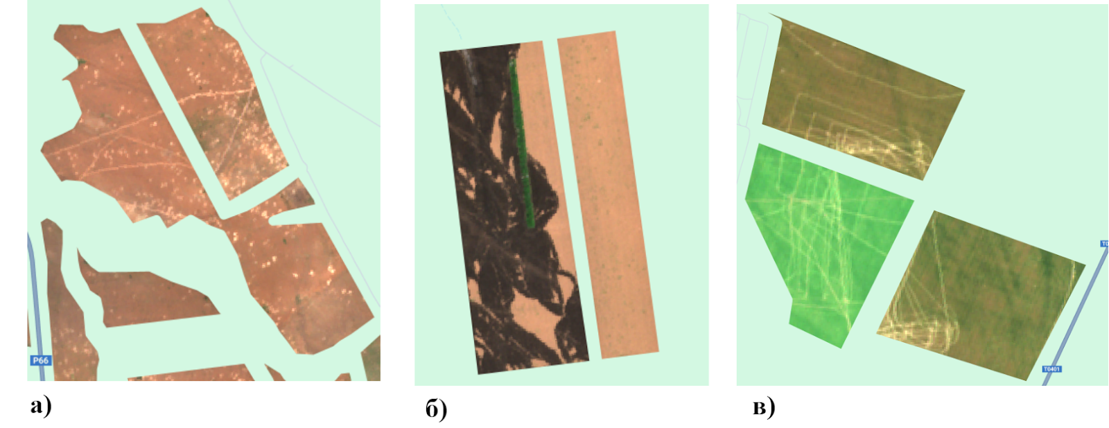
KPI used that data to develop an algorithm for automatic detection and monitoring of damaged fields, a tool which enables obtaining detailed imagery using machine learning methods. The use of spectral ranges (resolution of 10 meters), vegetation indices and their statistical characteristics in time series, it was possible to achieve an accuracy of about 85% in determining damaged areas.
This model is capable of identifying various types of damage, including shelled, burnt fields and areas damaged by trenches or military vehicle movements.
Researchers used satellite data, date of image collection and the class of crop grown in the field prior to the damage occurring to identify approximately 743,500 hectares of agricultural land in ten Ukrainian regions that were damaged in 2022. In 2023, another 801,000 hectares of damaged fields were additionally identified, and as of August 2024, another 366,000 hectares. Using these numbers, it is estimated that roughly 1.91 million hectares of agricultural land have been damaged since the war began.
It was found that significant losses of agricultural land occur in spring and summer, in particular between March and September, a period that coincided with the timing of active hostilities. At the same time, while damage mainly included shelled areas in 2022-2023, in 2024 traces of field entrenchment and burned areas were observed in fields.
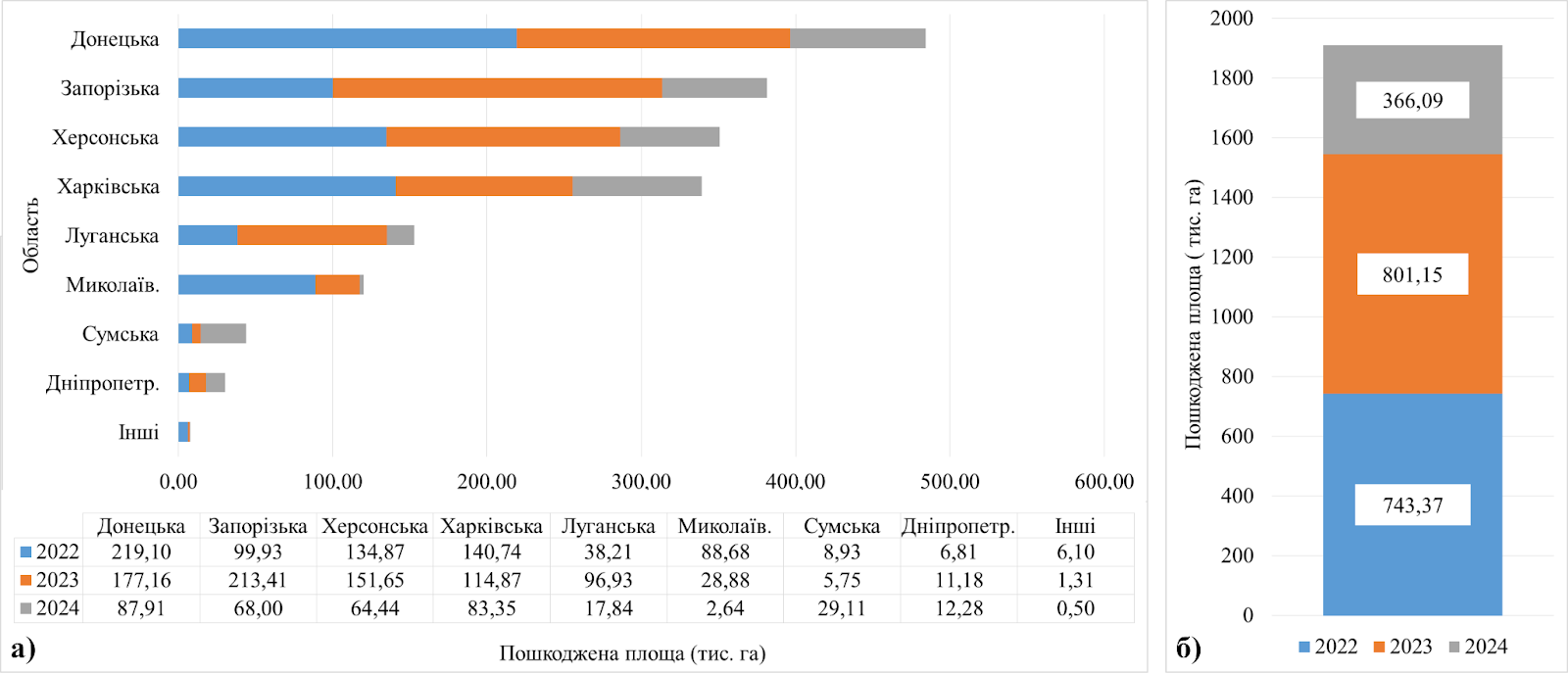
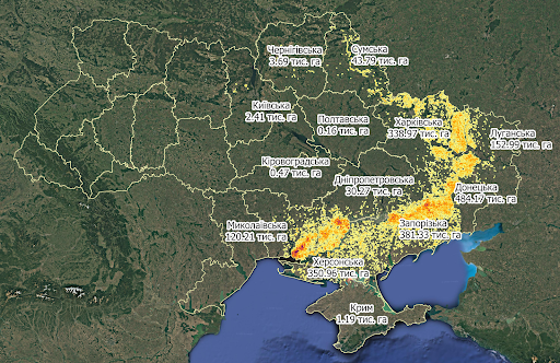
Analysis by region shows that the largest area of damaged agricultural lands was recorded in the Donetsk region, where approximately 484,100 hectares were damaged during these three years of full-scale war, comprising over 25% of the total area of damaged lands. In second place is Zaporizhzhya region, with 381,000 hectares of damaged land (20%). In the Kherson and Kharkiv regions, losses totaled 351,000 hectares (18.4%) and 339,000 hectares (17.7%), respectively.
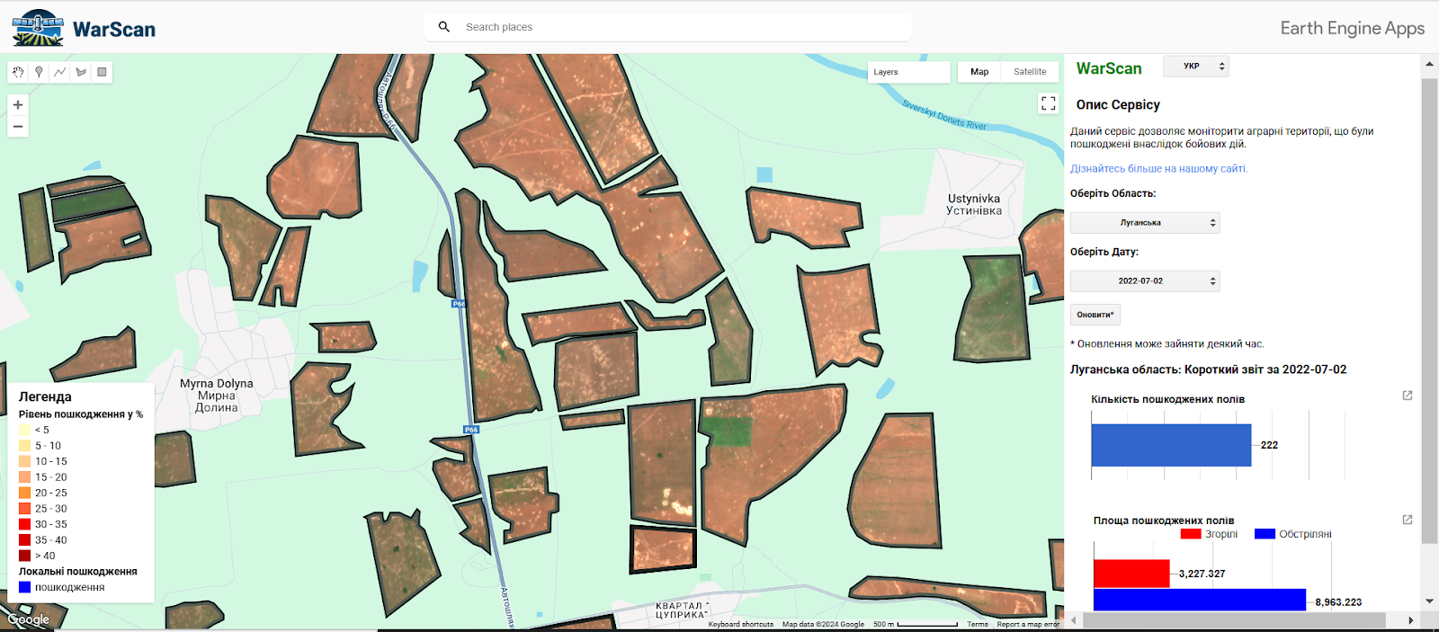
In order to track damaged fields and with support from the National Research Foundation of Ukraine (NRFU), MMDA scientists created the “WarScan” geoportal prototype within the framework of the “Geospatial system for monitoring the impact of war on agriculture in Ukraine using satellite data” (2023.04/0039) project. The geoportal operates in the Google Earth Engine (GEE) cloud environment and contains vector boundaries of damaged fields, raster masks of local damage with specific information regarding when damage occurred, damaged areas and the extent of damage to each field, while also allowing users to directly view satellite images where damaged fields were detected. There are future plans to expand the geoportal’s functions by adding information regarding type of damage and the ability to download data and issue regular automated updates.
This methodology allows damage information to be updated even in the presence of cloud cover or changes in vegetation, making it extremely useful for automated satellite monitoring of the war’s impacts on agriculture. The data collected contribute to recovery assessment, strategic planning and documentation of war crimes related to the destruction of agricultural resources. Rapid loss estimates are essential for quantifying crop damage, as well as for decision-making on food exports and pricing.
View of the war’s environment and environmental challenges
The war in Ukraine has created serious environmental challenges for agricultural lands, challenges that force a rethinking of approaches to land use and restoration.
It is known that explosion craters can persist in fields for years, and natural restoration processes are not able to quickly level the landscape. As an example, there are still areas in Europe where craters from the First and Second World Wars are still visible, and cultivated lands may still show traces. Such damaged areas require environmental reclamation in order to be used fully for agricultural purposes.
Restoration of damaged lands depends on the extent of degradation, pollution levels and the political situation. Only about a third of damaged fields are returned to cultivation, with two-thirds remaining abandoned. Abandoned areas are initially replaced by thistle (Carduus sp.), wormwood (Artemisia sp.) or and goosefoot (Chenopodium sp.), helping to stabilize soils. Such lands may subsequently transform into semi-natural meadows or shrubby thickets, losing the opportunity to return to traditional agriculture.
Soil erosion is one of the most serious consequences of military action. Explosion craters create uneven surfaces that become areas of increased erosion. Rainwater and winds wash away the uppermost, fertile layers of soil faster, while soil compaction by heavy equipment such as tanks or artillery tractors further aggravates the problem. Movement of military vehicles disrupts the structure of the soil, compressing it to the point where water and plant roots cannot penetrate deeply. This leads to the formation of stagnant areas and further soil depletion. Such areas require significant effort to restore fertility including deep ploughing, soil amendment and bioremediation.
In addition to physical damage, military action also leaves lands chemically polluted. Heavy metals such as strontium, copper, zinc, nickel and chromium accumulate in soils, leading to soil oxidation and the formation of toxic organic compounds. Damage to soils heightens the challenge of growing crops and encourages the spread of pollution-resistant plants. Less demanding crops, such as cereals, sugar beets or potatoes can grow on such lands. However, eating crops from contaminated areas poses a health risk to humans and animals.
Leaving fields uncultivated in the long term creates both challenges and new opportunities. On the one hand, uncultivated fields suffer from erosion, can become overgrown with weeds and lose their agricultural function. On the other hand, such lands can be used for other agricultural projects, including those that are environmentally friendly. For example, converting damaged lands into pastures reduces plowing and ecosystem load, which will, in turn, help preserve soils, reduce erosion and improve water balance. Afforestation and restoration of natural areas by reducing the area of agricultural land are globally successful practices. Planting forests on degraded lands can reduce the risks of erosion, improve water resource quality and even create new habitats for wildlife.
Another option is to grow energy generation crops such as osier willow (Salix viminalis) or silvergrass (Miscanthus sp.), which not only provide renewable energy but can also help to clean soil. However, scientists have not yet reached consensus on the potential danger of using osier willow in areas contaminated with toxic substances and whether its use is safe for the environment and health. Proper disposal of residues after burning plants that may contain heavy metals is also important.
The war has also forced a rethinking of land use in Ukraine. Abandoned or damaged lands can become the basis of new strategies, from conservation and organic farming to the creation of nature reserves or use for energy crops. Although this may reduce agricultural potential in the short term, such changes can stabilize ecosystems and create conditions for sustainable development.
Importance of satellite monitoring in wartime
Satellite monitoring is an indispensable tool for studying the consequences of war on agriculture and the environment in that it provides objective and large-scale situational assessments where traditional methods of collecting information are impossible or extremely limited. In Ukraine’s occupied territories, in active combat zones or in mined areas access to field observations, ground measurements or aerial photographs is dangerous or technically impossible. In such conditions, only satellite data allows obtaining regular, real time and accurate information on the status of agricultural lands.
Analysis of remote-sensing data enables both documentation of the overall reduction in the area of arable land and also identification of specific types of damage left by military actions. For example, Sentinel-2 optical imagery allows identification of burned areas, explosions or trenches, while radar data from Sentinel-1 can detect changes in soil structure even under cloud cover or at night, both of which are inaccessible for traditional methods. This is important for assessing long-term environmental impacts; satellite observations can record increased erosion, soil compaction from heavy machinery or land contamination with toxic substances that cannot be detected on the ground without special equipment.
Satellite data allows us to assess not only damage, but also the speed of agricultural recovery. Analysis of vegetation indices can track whether land is being returned to cultivation, what crops are being planted after destruction, and identifying regions where agricultural production remains impossible. Real-time observations enable assessment of how agriculture can be adapted for new conditions, the rate at which farms are returning to land cultivation, and which regions need priority assistance. KPI’s WarScan geoportal facilitates centralized monitoring of damaged areas, recording new cases of field degradation, and creating a database for future recovery strategies.
Satellite monitoring is an indispensable tool in wartime, providing objective assessments of the war’s impacts on agriculture, enabling monitoring of environmental risks and helping to effectively plan recovery processes even in the absence of access to traditional sources of information.
Leonid Shumilo (University of Maryland, USA), Sofiya Drozd (Kyiv Polytechnic Institute), Natalya Kussuk (University of Maryland, USA)
Translated by Jennifer Castner
Main image source: Mathematical Modeling and Data Analysis department at Igor Sikorsky Kyiv Polytechnic Institute